SaveGREEN - Around the World in Green Infrastructure
23-09-2022
SaveGREEN is primarily focused upon protecting and strengthening key ecological corridors in the Danube basin, but ecological connectivity is a concern around the world. What do we have to learn from international green infrastructure projects?
In a previous article, we explored some best practices for European green infrastructure, discussing the benefits and challenges of strengthening ecological connectivity on the continent. We should not restrict our sights to Europe, though: ecological connectivity is a concern for planners around the world, and innovative examples of green infrastructure can be found worldwide. Often, as environmental organisations and planners deal with the unique biota of their location, creative solutions emerge, from which we can take inspiration for our own contexts. With this in mind, CEEweb is working within the SaveGREEN project also look to the rest of the world for applied knowledge, informing practices for crucial human-wildlife conflicts on roads being used back at the project’s home in the Danube basin.
It is not uncommon that we find ourselves concerned with ecological connectivity as a relatively abstract concept. Indeed, as ‘green’ planners, it often takes our GIS-based mapping and tracking of habitats to consider where animal species might move and plant species distribute. On Christmas Island, legally territory of Australia, a world-famous migration of red crabs (Gecarcoidea natalis) takes place yearly, with millions simultaneously migrating from the island’s forests to the sea for spawning. In other words, this movement of fauna makes itself well-known to everyone on the island, the crabs asserting their need to be accommodated by the island’s infrastructure. This force of nature, especially popularised in BBC documentaries of David Attenborough, blankets the island, covering roads, walkways, and effectively the entire mobility network. As media and cultural studies professor Philip Hayward has put it:
“The resultant so-called “red tide” moves across roads and through properties, along routes established in the pre-human era, in what is now an annual distraction to traffic flows and to everyday human life.” (p238)
Governors of the island have therefore had to implement a plethora of measures to respond to the crabs’ demand for mobility, and to reconcile this with the mobility needs of the islands’ humans. Historically, these were limited to sporadic road closures, with relative negligence for the crabs. In the last decade or so, a thorough, mixed-methods, island-wide effort has been implemented to avoid conflict between the travel routes of migrating crabs and cars over the roads. A network of underpasses and bridges for the crabs to traverse roads safely, with fencing to guide them toward these crossings, has paired with comprehensive awareness-raising campaigns for locals and tourists alike, creating a holistic mitigation strategy against interruption of the migration paths. Road closures are also still implemented, albeit more sparingly, in the densest paths of migration, particularly within the island’s protected areas; these closures are respected and understood to a wider extent amongst the public however, thanks to the educational campaigns about the importance of the crabs to the local environment. On the whole, this operation represents a major success: key human transport corridors remain available, while key migration routes remain undisturbed. The infrastructure built for crab movement has even become a viral tourist attraction as much as the migration itself, particularly the famous ‘crab bridge’ which becomes awash in red each year.
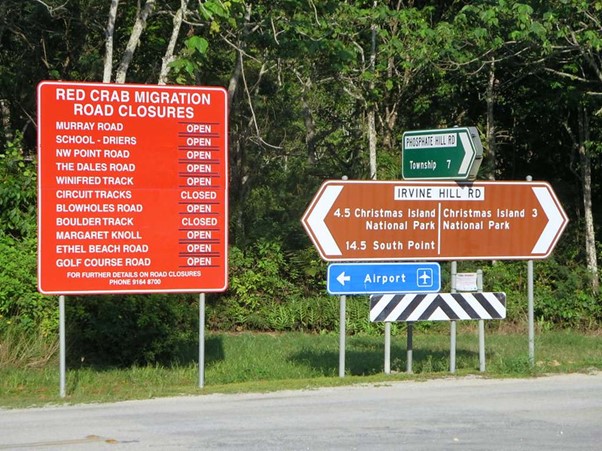
Image: signage for Christmas Island road closures due to crab migration. Road closures are a temporary inconvenience, but infrastructure for crab crossings is helping to minimise disruption, and awareness-raising campaigns have made locals more understanding of the need for road closures. Source: David Stanley, Flickr
While the island location of this Christmas Island infrastructure, as well as the extent and simultaneity of the crab migration, may not be directly comparable to any processes of concern in the Danube basin, we can still take key lessons from this project. Firstly, this project was responsive to the needs of the species of concern, namely the crabs: a holistic system was planned to zone infrastructure, closing roads where crab movement is densest, while placing infrastructure for crabs’ road crossing strategically elsewhere along roads where the movement of cars is also vital to social systems. Therein, a solution was developed which did not compromise on the conservation imperatives of the migration, and in this case, an educational campaign served to make locals and tourists aware of the need for temporary inconvenience in some cases to protect vital crab movements. Furthermore, this effort shows that with innovative design, green infrastructure for ecological connectivity need not be a begrudging expense to ‘soften the blow’ of transport infrastructure: as with the Christmas Island crab bridge, these green infrastructure forms can become valuable attractions in themselves, and net contributors to the landscape. There are key takeaways therefore for integrating creativity and holistic, conservation-led approaches into green infrastructure planning, which as such do not require drastic compromise on social and economic outcomes.
Once again, though, Christmas Island is just one island, and does have the privilege of requiring infrastructure to accommodate only relatively specific ecological processes (primarily the crab migration). In the Danube basin, dealing with the establishment of connectivity at far greater scale, it would be impossible to expect comparable levels of precision and intricacy in design and placement of all green infrastructure. These insights can certainly inform specific infrastructure projects, but at the macro scale, we can also look to larger-scale spatial planning of ecological connectivity around the world. An example of such a major ecological connectivity project is the Terai Arc Landscape (TAL), with a system of corridors largely implemented with the cooperation of the Nepalese Government and the WWF, but also crossing into northern areas of India. The region is a vital habitat for key species such as the Bengal tiger and greater one-horned rhinoceros, but it is simultaneously described as the ‘rice bowl of the country’, hinting at the overlap of vital conservation and agricultural interests. The Terai Arc conservation project takes a landscape approach to reconciling these interests, modelling tiger habitats and roaming routes, alongside agricultural productivity and areas of concentration, to develop a research-driven approach to recommended land use. The spatial planning strategy therefore connects strictly protected areas with dedicated mixed-use corridors which are designed to allow continued animal movement without excluding agriculture from entire regions. This corridor land use system is typically achieved through agroecological approaches to crop growing, and by implementing fenced buffer areas around fields to direct animals across land while minimising impact on crops and livestock.
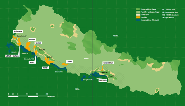
Image: map of protected areas and corridors in Nepal, including selected protected areas included in the TAL in north India. The TAL stretches along the south to the southwest of the map, with corridors and protected areas highlighted. Source: WWF Nepal
While there is still work to be done, this corridor approach has been useful in linking the protected areas in the west of the TAL, amplifying the effects of each and bolstering the resilience of the vulnerable tiger and rhinoceros species. While this corridor approach is not novel to conservationists in Europe, its extent and ambition is certainly something to be commended, as well as its agroecological approach to large-scale corridor construction in agricultural areas. In particular, it is useful to consider the potentials for holistic strategy on a large scale to combat some of the issues identified in the previous article: namely, an approach which constructs grey infrastructure first, then attempts to implement ‘greening’ measures later, often at greater cost and lesser efficiency. Indeed, this is the goal of SaveGREEN, to generate a coherent framework for connectivity planning in the Danube region, so that avoiding fragmentation and restoring connectivity becomes a primary concern of infrastructural development. The Terai Arc highlights the international precedent for this effort, pointing to the utility of continued interaction with global projects to inform the way forward.
In closing, then, there are clear insights to be gained by looking to connectivity projects around the world, which have displayed creativity, ambition, and precision in distributing and managing socioeconomic and ecological priorities. As SaveGREEN looks to place regional infrastructure at the cutting edge of connectivity projects, it therefore calls on practitioners to leave no-stone-unturned in the search for inspiration regarding the best green infrastructure methods being employed today. Indeed, this is in the hope that the Danube basin will one day itself be a global source of inspiration for effective ecological connectivity planning. The examples explored here have emphasised the crucial importance of a multiscalar approach, which considers the finer design intricacies of specific locations’ green infrastructure, as well as the macro-scale picture of connectivity and legislative protections.
Resources
Christmas Island Tourism Association (2015) “20km of barriers, 31 underpasses and 1 bridge: getting ready for the great crab migration” [online, accessed 15/09/2022]. Available at: https://www.christmas.net.au/20km-of-barriers-31-underpasses-and-1-bridge-getting-ready-for-the-great-crab-migration/
Hayward, P. (2021) “Embodying the Anthropocene: Embattled crustaceans, extractivism, and eco-tourism on Christmas Island (Indian Ocean)”, Island Studies Journal, 16 (1), pp.229-248 [online, accessed 15/09/2022]. Available at: https://researchportal.scu.edu.au/esploro/outputs/journalArticle/Embodying-the-Anthropocene-Embattled-crustaceans-extractivism/991012948499102368
Sargent, A. (2015) “Forget Sydney and San Francisco, Christmas Island crab bridge helps migrating critters beat the traffic”, ABC News [online, accessed 15/09/2022]. Available at: https://www.abc.net.au/news/2015-12-09/bridge-helps-migrating-christmas-island-crabs-avoid-traffic/7014406
WWF Nepal (2022) “Terai Arc Landscape (TAL)” [online, accessed 15/09/2022]. Available at: https://www.wwfnepal.org/our_working_areas/tal2/
Author:
Elliot Cocker, CEEweb For Biodiversity
Contributed by:
Lily Tanui, CEEweb For Biodiversity