ConnectGREEN - Identifying core areas and ecological corridors for large carnivores in the Carpathians
12-11-2020
The ConnectGREEN project aims to maintain and improve the ecological connectivity in the Carpathians. This is a highly complex task that requires good planning and cooperative management across the entire mountain range. A crucial element to such an endeavor is the availability of solid data on which project partners can base their efforts.
A clear and understandable visualization of ecological networks on the map is an important tool for communication between different stakeholder groups and facilitates finding solutions in a field defined by an abundance of varied and often diverging interests.
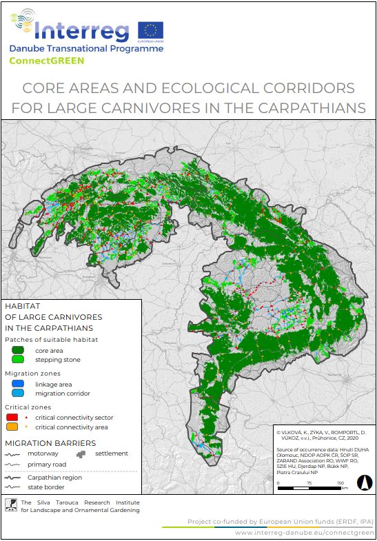
Based on the Methodology for identification of ecological corridors, which was developed during the first phase of ConnectGREEN’s implementation, a team of experts worked for more than a year on the development of a map of core areas for large carnivores and ecological corridors of transnational relevance in the Carpathian ecoregion.
The team, which is comprised of experts from all project countries, was led by the Czech project partner Silva Tarouca Research Institute for Landscape and Ornamental Gardening (VUKOZ) with the strong support of experts from the Nature Conservation agency of the Czech Republic (NCA CZ).
Although the task of acquiring the data on time in sufficient quantity and quality proved challenging, the project team succeeded to consolidate the information needed for further modelling. The state-of-the-art methods anchored in the Methodology were applied in the process of the development of the map of core areas and ecological corridors.

Figure 1.: Map of core areas and ecological corridors of large carnivores in the Carpathians © VUKOZ
After extensive work on the data and numerous periodic verifications by experts from the local and national level, the final draft of the map was presented at an international workshop held on the 30th October 2020. Due to Covid-19 restrictions, the workshop took place online. In total, 33 experts from seven countries participated in the workshop. Representatives from VUKOZ explained to participants, what procedures were followed in the development of the map and finished by presenting the results of their work. The map was showcased in an interactive form, which enabled participants to delve into more detail and to have a concrete and precise discussion about the map’s features. Details regarding the data used in the modelling, the verification methods and potential further discussions at the national level were discussed.
Participants showed great appreciation for the work performed by the ConnectGREEN team of experts and voiced their interest to receive the final results. Moreover, they offered several recommendations towards the improvement of the map and expressed their willingness for future cooperation.
