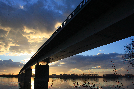
Water Contingency Management in the Sava River Basin (WACOM)
This is the first newsletter in which we would like to present some achievements gained in the first 6-month period, on Work package T1: Explore and define joint preparedness and response and on Work Package T2: Develop joint preparedness and response toolbox.
Introduction of the WACOM
The Water Contingency Management in the Sava River Basin- WACOM is an EU project co-financed by the Interreg Danube Transnational Programme which started on the 1st of July 2020.
The main objective of the project is reduction of the environmental risks related to accidental pollution and floods, especially those that have or could have a transboundary impact in the Sava River Basin. It is focused to the implementation of the three protocols to the Framework Agreement on the Sava River Basin, signed and ratified by the Bosnia and Herzegovina, Croatia, Serbia and Slovenia, i.e. the Protocol on Emergency Situations, the Protocol on Prevention of Pollution Caused by Navigation and the Protocol on Flood Protection. Two of the protocols are in force, while the final harmonization of the Protocol on Emergency situations is expected in the first half of 2021.
The specific objectives are
- Improved transnational procedures for response to accidental pollution and floods;
- Improved transnational cooperation among civil protection, water management and navigation agencies;
- More efficient joint response in the case of accidental pollution/flood emergencies on international Sava river basin.
The main result will be reduced risks induced by the accidental pollution and floods of transnational dimension by strengthening the transnational and trans-sectorial cooperation among institutions, especially governmental institutions (responsible for the water and flood management and the civil protection) managing the flood and accidental pollution preparedness and response stage. The successful implementation of the project activities is ensured by the transnational and trans sectoral partnership led by the University of Ljubljana, which includes international, national/entities authorities and research institutions dealing water management, civil protection, and navigation from the Sava River riparian countries.
The activities are divided in four work packages as shown below:

Figure 1: WACOM work packages:
WP T1 – Explore and define joint preparedness and response
WP T2 – Develop joint preparedness and response toolbox
WP T3 – Verify joint preparedness and response- pilot implementation
WP T4 – Strategy for the implementation of coordinated preparedness and response
At present the implementation of the project is focused to the WP T1, WP T2 and to communication with target groups.
Work Package T1: Explore and define joint preparedness and response
Leader of Work Package T1 is Association for Risk Management (AZUR), and all project partners participate in it. The goal of the Work Package activities is to analyze the existing protocols and pathways to their operational status. To this end, work is underway by mapping existing structures, processes, and activities within three areas - civil protection, water management, and river navigation - with a special interest in existing procedures in force regarding accidental pollution and flood emergencies. The entire mapping process is carried out to achieve the following targeted results: mapping of the institutions and procedures relative to the coordinated planning and response; development of specific mapping and strategy for the navigation and related contingencies; harmonization of the contingency structures and procedures; process of the data collection.
Work is currently underway in this part of the project on data collection regarding the institutions and procedures related to coordinated planning and response. All relevant data on institutions and procedures at different levels (strategic, tactical, and operational) in five countries (Slovenia, Croatia, Bosnia and Herzegovina, Serbia, Montenegro) as on the international aspect of cooperation within the Sava River Basin are collected.
To have a unique methodological approach in the process of mapping and data collection, a Guidance document for the status identification process and eleven related tables were prepared and submitted to all project partners who use them directly and in cooperation with various stakeholders to collect the required data. The data collection process itself has been slowed down due to the situation related to the COVID-19 pandemic and the focus of stakeholder institutions on this topic.
The data collected so far, as well as those that will be collected by the end of the mapping process, will be analyzed within four different matrices (at the state level; at the international level; interdisciplinary between countries and the international level; data interpretation according to the ICS concept). The analyzed data will have a dual purpose. In the first, it will serve for the realization of all work tasks (outputs) within this work package, such as: report on the mapping of the institutions and procedures relative to the coordinated planning and response; report on the methodology for the state workshop development; preparation of the state and regional workshops; report on a methodology for the regional workshop development on navigation emergencies; making strategies for the implementation of the protocols to the framework agreement on the Sava river. The second purpose of the collected and analyzed data is to prepare the basis for activities and work in all subsequent work packages, primarily in the Work Package T2.
Work Package T2: Develop joint preparedness and response toolbox
The main goal of the Work Package T2 (WP T2) is the development of a rapid joint preparedness and response toolbox, which will be built upon the exiting and operational family of tools developed and used by the International Sava River Basin Commission (ISRBC), i.e. GeoInformation System for the Sava River Basin (Sava GIS), Hydrological Information System of the Sava River Basin (Sava HIS) and Flood Forecasting and Warning System in the Sava River Basin (Sava FFWS). The leader of WP2 and the coordinator of the development of the toolbox is University of Ljubljana (UL), with other project and domain partners (e.g. civil protection and water authorities) also being involved in the toolbox development process.
The current work within WP T2 is focused on the development and running of initial two-dimensional (2D) hydraulic models, which will form the basis for subsequent oil spill modelling. The first step was the selection and testing of an appropriate hydraulic and oil spill model, with the OilFlow2D model being selected as the preferred choice. OilFlow2D oil spill in water component computes oil trajectories in rivers by incorporating the effects of oil weathering processes (i.e. evaporation, emulsification, dissolution and interaction of oil with shores), with the OilFlow2D computation engine being based on an accurate, fast and stable finite-volume solution method. The oil spill modelling is based on the precalculated hydraulics of the river section, which thus enables simple development of different oil spill scenarios and faster oil spill model runs. The testing of the OilFlow2D model can be seen in Figure 1, while the example of the model output is shown in Figure 2.
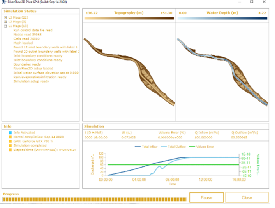
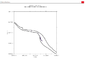
Figure 2: The calculation of the river hydraulics (left) and oils spill propagation (right) in the OilSpill2D model

Figure 3: An example of the model output (in this case the oil spill tracking feature) in the OilFlow2D modelling suite
After the selection of an appropriate model, the next step has been the preparation of the topographical data that is needed to develop 2D oil spill models of different modelling section along the River Sava. An in-house developed tool has been used, which generates a three-dimensional (3D) topographical grid of the river channel from surveyed channel cross-sections, i.e. geodetic profiles that have been taken for the purpose of developing a one-dimensional (1D) hydraulic model in HEC-RAS. Finally, the work currently revolves around developing of 2D hydraulic models for different model sections along the Sava. The River Sava has been divided into 31 modelling sections, with the model limits being set at natural boundaries (e.g. river confluence) or at relevant infrastructure (e.g. ferry line, harbour etc.). The idea has been to divide the river in different modelling sections by considering where the potential source of pollution might occur or the spilled oil might enter the main river channel (e.g. confluence, industrial complex etc.) and where the potential response and mitigation measures might be employed (e.g. ferry line, bridge etc.). An example of the initial 2D hydraulic model developed in the OilFlow2D model can be seen in Figure 3.
Figure 4: 2D hydraulic model for the section between the confluence of the Bregana River and the Sava (upstream) and the confluence of the Krapina River and the Sava (downstream). The red line outlines the model extent, while the black lines show the computational mesh
The work within the WP T2 in the near future will focus on the refinement of hydraulic models and development and running of oil spill models for individual model sections. Once the modelling is completed, this will be the basis for the next step in the development of the response toolbox, which will include the development of graphical components of the response toolbox and integration with already functional operational tools, such as SavaGIS and SavaHIS.
Communication with target groups
Kick-off conference and other international events
Communication with stakeholders and the wider public has been an important part of the project activities from the very beginning. We have identified more than 500 institutions from national/entity authorities, regional and international institutions, infrastructure companies, enterprises, research institutions, NGOs and the media to be contacted during the project lifetime, not only to disseminate the information, but also to actively involve the relevant stakeholders. This is the basis to ensure sustainability of the project result after the end of the project.
The Kick-off conference of the WACOM project was held due to Covid-19 crisis via teleconference on October 16, 2020 aiming that the wider public get the basic information on the Project, Danube Strategy, and Interreg Danube Transnational Programme. The conference gathered more than 70 participants from project partners, ministries, directorates, water agencies, hydrometeorological institutes, local authorities, enterprises, and international organizations.
At the conference, the project partners presented the WACOM project, its main objectives, results and outputs. Particular intention was paid to the implementation of technical work packages from WP T1 to WP T4. After the introduction of the project the panel discussion was organized on international and cross-sectoral cooperation on accident pollution and flood management and assessment of potential impact of the project to these issues.
The WACOM project was also presented at different events and Steering Group meetings of the Priority areas of the EU Danube Strategy, i.e. PA4 Water Quality and PA5 Environmental Risks. The aim of these meetings was to provide the information of resent activities to the members of SGs and the partner organizations like International Commission for Protection of Danube River, EU Commission, Danube Strategic Point, Carpathian Convention and Global Water Partnership.
An important feedback was also provided by the Permanent Expert Groups established by the International Sava River Basin Commission for navigation, for river basin management and for the accident prevention and control held in October and November 2020.
Upcoming events
In February and March 2021, the national and regional workshops will be organized to present and validate the main findings of the WP T1 on the operational procedures and protocol implementation at national and international level. The outcomes of these workshops will help the project partners to improve the outcomes of other work packages and prepare the basis for the further development of joint preparedness and response toolbox (WP T2) and implementation of pilot actions (WP T3).
We would like to invite you to follow the activities on the WACOM project at the project web site and social media, i.e., Facebook and Twitter where the upcoming events will be announced in a due time and the information on the implementation of the WACOM project will be regularly updated.
