|
|
| |
| |
 |
What has DanubeSediment been working on?
|
| |
|
A lot of things have happened since our last newsletter. DanubeSediment was very active in → social media by publishing and promoting its first project video. The first reports on → sediment data monitoring and data analysis have also been published! What are these project reports all about? First, DanubeSediment analysed the available sediment data and the monitoring methods used by the Danubian countries. This builds the foundation for the sediment balance, which will identify changes and show reaches with sediment surplus and deficit over different time periods. You can read more about the complexity of assessing the morphological development of the Danube in the section → finalising the sediment balance.
The project also took a look at the reasons for these changes and published them in the report on → drivers and pressures of changes in the sediment regime. To support the restoration of the sediment balance, the project team is currently collecting and evaluating “good practice” measures. These will be included in the Danube Sediment Management Guidance for decision-makers and the Sediment Manual for Stakeholders.
One of the key goals of DanubeSediment is to raise awareness for the need of international sediment management along the Danube. We therefore put a strong focus on → translating our project results for stakeholders, making them both understandable and usable for decision-makers and practitioners working in the field of sediment management.
Check out our website for information about our last project meeting in Munich in March 2019 and about upcoming project events such as the International Stakeholder Workshop on Measures on 26 June in Bucharest and Danube Day activities near you!
|
|
| |
 |
DanubeSediment in social media
|
| |
 |
|
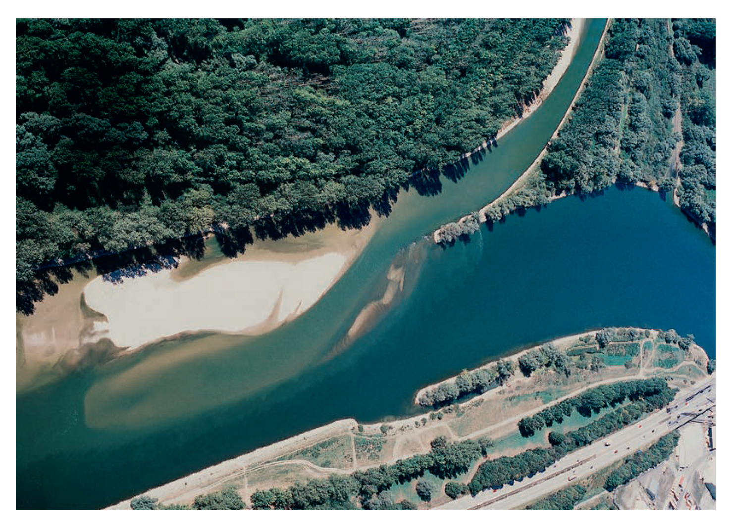
In our last newsletter, we encouraged you to vote for your favourite photos in the Danube Transnational Programme Photo Competition. We are proud to announce that one of our photos was voted into the Top20 (see the left image, showing the confluence of Isar and Danube)! The prize was to have postcards printed, which were distributed at the Annual Forum of the EU Strategy for the Danube Region and by our project partners at local events.
|
|
 |
|
Our first project video is now online! Thanks to our partners, the video has not only been posted on YouTube, Facebook and Twitter but also shared and liked many times with thousands of views. We are very happy about the great feedback! If the video has not reached you yet, then check it out here! (Subtitles available in several languages)
|
|
| |
|
Sediment data monitoring and data analysis
|
| |
|
The first report on “Sediment Monitoring in the Danube River” describes the methods used by the Danubian countries to monitor sediment and to calculate the sediment load. A majority of the stations, in fact 75, collect data on suspended sediment, such as silt and clay, while only eight stations continuously collect data on bedload, such as gravel and sand.
Not only does the report describe past and current sediment sampling methods but it also recommends “good practice” methods. Those readers especially interested in the topic can read the “Handbook on Good Practices in Sediment Monitoring”, which summarises instructions and practical recommendations to optimise monitoring stations and methods.
In the big report, you can also find recommendations for improving sediment monitoring. For example, bedload transport should be monitored more often, especially during high water flow, since it has a strong impact on river morphology. The report also suggests a Danubewide data management network, which will help pave the way for international cooperation to restore the sediment balance of the Danube.
So how much sediment does the Danube transport? And how has the balance changed? As a precondition for the sediment balance, our project team collected and analysed an enormous set of sediment data during the past two years. The “Analysis of Sediment Data Collected along the Danube” takes a first look at this data, for example the quantity and quality of sediment data collected in each country. Since the Danube-wide sediment balance can only be calculated if all data is compatible, the project needed to harmonise the data. Discrepancies in data may occur when comparing data from different measuring instruments, for example at border sections.
Find out more in the full reports that include interesting photos and figures like the following one. Here you can see that large flooding events, e. g. in 2002, 2006 and 2013, transport enormous amounts of suspended sediments.
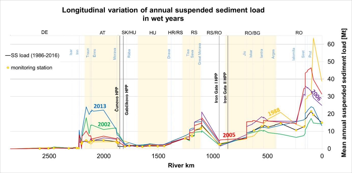
Longitudinal variation of annual suspended sediment load along the Danube River in wet years (BME, 2019)
|
|
| |
|
Finalising the sediment balance
|
| |
|
During the past half-year, the sediment balance activities focused on statistical analyses of discharge and suspended sediment load and the temporal and spatial variability of the individual sediment balance components. Suspended sediment budgets were prepared for partial river reaches, looking to compare the balance before and after the building of the major dams. As seen in the figure above, hydropower plants in the river strongly reduce the amount of suspended sediment transported since they function as sediment traps. For example, first analyses show that for the Romanian-Bulgarian and Romanian reaches up until the Danube Delta, the long-term suspended sediment load decreased by more than 60% compared to historical data from before the construction of the hydropower plants. In
addition, the morphological development of the Danube is analysed. This means that we are calculating the sediment erosion or deposition for partial reaches based on channel bathymetry data.
Since the national methodologies to monitor river bed changes strongly differ in time and space, we are paying great attention to the interpretation of the data. Different issues need to be tackled, e. g. the role of dams or the lack of data time series.
Data about river bed changes needs to be coupled with dredging and feeding data, changes in longitudinal profile, slope, bed material composition etc. To support this analysis, historical maps from the end of the 19th century are used to identify reference conditions and to determine changes, such as river types, river width and river length. The analysis of the morphological development will identify river reaches with long-term erosion, sedimentation or dynamic stability.
|
|
| |
|
Drivers and pressures of changes in the sediment regime
|
| |
|
The report on the “Interactions of Key Drivers and Pressures on the Morphodynamics of the Danube“ describes the human activities that impact the sediment regime. It concludes that for the Danube and the 19 major tributaries, flood protection and hydropower are the main drivers generating significant pressures on the transport and continuity of sediment (see next figure). If we only look at the Danube River, navigation is also a main driver. The analysis also showed that interruptions of longitudinal continuity and lateral connectivity, e. g. dams, weirs, groynes, ship locks and sluices, dykes, dredging, regularization works, artificial channels etc. are rated as significant pressures. You can find the full report, including many figures and maps that visualise the results and their distribution along the Danube, under this link.
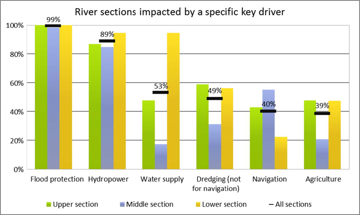
Percentage of river stretches to absolute length affected by key drivers on the Upper, Middle and Lower Danube River and the 19 major tributaries (NARW, 2019)
|
|
|
To determine the impact of significant pressures on the hydromorphological and biological elements for the entire Danube, the project is developing a risk assessment methodology. This methodology will be applied in pilot sites along the upper, middle and lower Danube sections. A synthesis report will summarise the main results of the risk assessment.
The most challenging task is currently the identification of “good practice measures” that improve the sediment regime. The measures will be structured according to types, i. e. technical, ecological, organizational (legislative, institutional, administrative) etc. as “factsheets” in a catalogue of good practice measures.
|
|
| |
|
Translating our project results for stakeholders
|
| |
|
One of the main goals of our project is to give an answer to whether “sediment” is a Significant Water Management Issue (SWMI) in the Danube. To promote the topic among relevant experts, our project partners BME and BOKU have regularly presented preliminary project outcomes at several ICPDR meetings. For example, they presented the annual suspended sediment load before and after the construction of hydropower dams as well as changes to the length and width of the Danube. They also discussed sediment imbalances, riverbed degradation and their consequences, such as the strong decrease of sediment inflow to the Black Sea. Based on these presentations and the subsequent discussions of ICPDR experts, “sediment” is set to become a sub-SWMI under the existing SWMI “Hydromorphological alterations”. ICPDR and the project consortium are currently preparing a text for the next report on “Significant Water Management Issues”.
Furthermore, the project is working on the Danube Sediment Management Guidance (DSMG) and the Sediment Manual for Stakeholders (SMS). Draft versions of the DSMG will be available for discussion at the next ICPDR meetings in spring and for the National Stakeholder Workshops in June/July 2019.
In addition to communicating our results to experts in sediment management, DanubeSediment is also building public awareness about the need for sustainable sediment management. This year, our project will once again join the Danube Day celebrations in June. A multitude of different events for old and young will take place, for example activity booths for children with games and information about sediment as well as workshops and high-level events. Stay up-to-date on our website and the ICPDR Danube Day website.
|
|
| |
|
Interesting links
|
| |
|
| |
|
Published by
|
| |
|
|
|
|
| |
|
If you have received this newsletter, you have been included on one or more of the Danube Transnational Programme/projects postal mailing lists. We are committed to respect and protect the privacy of personal data collected. We regard your personal data as confidential information and will never communicate it to third parties. Your personal data are used mainly for the express purpose of receiving the newsletter. Your mailing details may also be used by the DTP and its projects for information and dissemination purposes strictly related to the programme and its projects. If you prefer not to receive more of this newsletter and your data not to be used for dissemination purposes, you can unsubscribe by sending a reply email.
|
|
|
|
|
|
