DANUrB+ - THE ATLAS AIMS TO ENHANCE THE INTERNATIONAL VISIBILITY OF SMALL AND MEDIUM-SIZED CITIES AND TOWNS ALONG THE DANUBE
28-06-2021
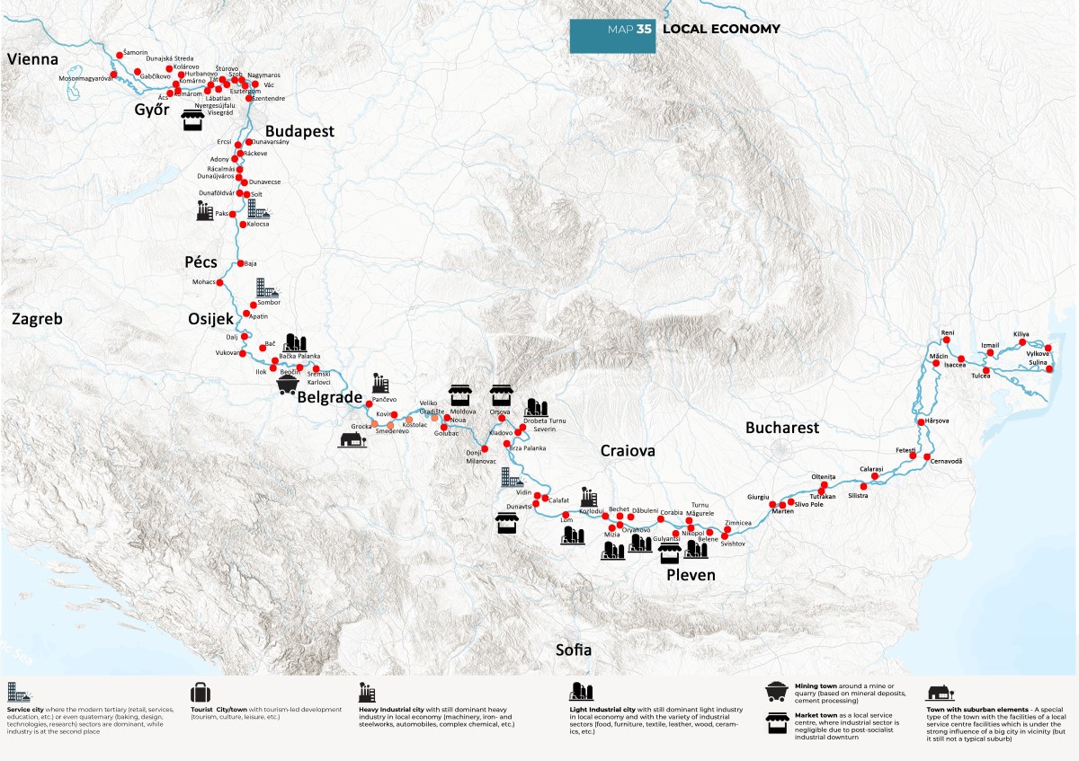
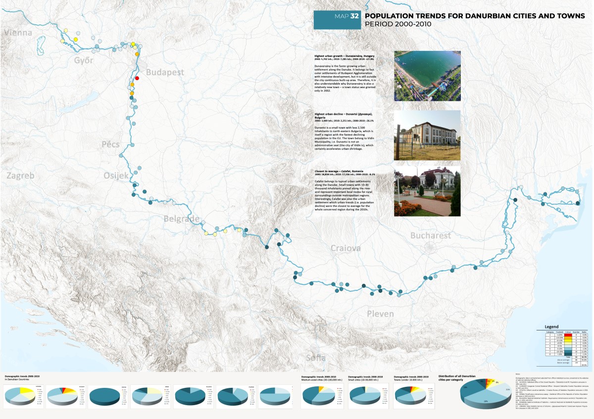
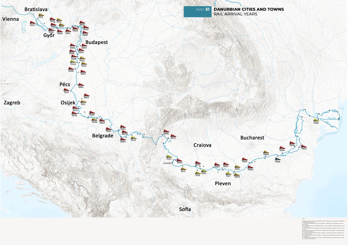
The Atlas of DANUrB+ cities is one of the key deliverables of Interreg DANUrB+ Project. The main aim of the Atlas is to enhance the international visibility of small and medium-size cities and towns along the Danube from Bratislava to the Delta through the comprehensive geographical and urban/morphological maps of these cities and towns, compiled and presented in an innovative way. These maps, supplemented by side-texts, diagrams, and photos, will cover their past and legacy/heritage, present challenges, and the future aspirations through local best practice. The Atlas will be prepared in both analogue/hardcopy and digital versions.
From the very beginning, the Atlas is a joint work of a huge author group from six Danubian countries: Slovakia, Hungary, Croatia, Serbia, Romania, and Bulgaria. The core of this group is six teams from the faculties of architecture and urbanism from five of these countries - from Bratislava, Budapest, Timisoara, Sofia, Bucharest, and Belgrade (leader). All core authors are organised in smaller author groups, which are responsible for the joint chapters of the Atlas about the specific topics important for the included Danubian cities and towns. The other authors from NGOs, public institutes, local and regional authorities are participating by collecting local data and providing support for fieldwork.
The Faculty of Architecture of the University of Belgrade, as a leader in the creation of the Atlas, is in charge for the proper systematisation, compilation, and revision of all received material, including joint chapters. Aside of this important task, the Faculty of Architecture of Belgrade is also responsible for the main maps of Danubian cities and towns regarding to their main characteristics: urbo-morphological, heritage-related, economic, demographic, and social. These maps will perfectly present a general insight of the urban development along the river, as well as the future perspectives of the cities and towns.
The Atlas is currently in the middle of its creation. During the first six months of the project in 2020, the basic data about the format, content and graphical standards of the Atlas were settled. The data of all included small and medium-size cities and towns (90 of them) are also collected and the first maps are recently prepared. The author teams for each joint chapter are organised in February-March 2021 and they are working on their chapters during summertime. The first Atlas to be edited is the analogue one. However, the main breakthrough is expected from the digital version, as more innovative; even though, the digital Atlas will use the same data, the digital approach enables new ways of presentation of content and interlinks between the different types of the Atlas content.
In such manner, the Atlas will show the Danube urban space as an “unity with local peculiarities” – the future cultural-tourist promenade of small cities and towns along the river as hidden European treasure, unified by the project.
------------------------------------------------------------------------
DANUrB+ project was launched in July 2020 to activate underused cultural heritage and resources on the peripheral and border regions along the Danube River. It is co-financed by the Interreg Danube Transnational Program 2014-2020. The expected result is to increase local development and international tourist attractiveness.
![]()
![]()
![]()
![]()
Project co-funded by European Union funds (ERDF and IPA).