|
|
| |
| |
 |
What has DanubeSediment been working on?
|
| |
 |
| |
|
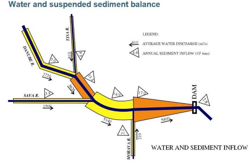
Figure 1: Schematic representation of the situation of water discharge and suspended sediment inflow in the Danube and its tributaries in Serbia (Source: Marina Babic Mladenovic, presented in Belgrade on 11/09/2017)
During the second half of 2017, the DanubeSediment project worked on two key pillars: the technical work focused on sediment data collection and homogenization; whilst in parallel, stakeholder involvement occurred throughout the Danube River Basin.
Data availability is only the first step towards analysing the sediment regime of the most international river of the world, the Danube. In order to provide comparable data sets for each country, the project partners addressed several important issues, e. g. data sampling methods, the frequency of data sampling, the subsequent aggregation of data, as well as the selection of appropriate timeframes for assessing historical changes. In addition, joint measurement campaigns contributed to harmonizing measurement methods used by the nine countries partnering in the project.
Representatives from water administration, research, waterway management, hydropower production, national parks, engineering and consulting companies, as well as NGOs were invited to national stakeholder workshops in Austria, Croatia, Germany and Hungary and Serbia throughout the past months. Their goal was to build up and exchange knowledge on sediment management in the Danube Basin. National workshops in Bulgaria, Romania, Slovakia and Slovenia are scheduled for the first quarter of 2018. Furthermore, International Training Workshops are planned in 2018 to ensure the transfer of knowledge on measurement methods and further technical issues to key target groups.
Find up-to-date information, news and photos on our DanubeSediment website.
|
|
| |
|
Assessment of sediment data
|
| |
 |
| |
|
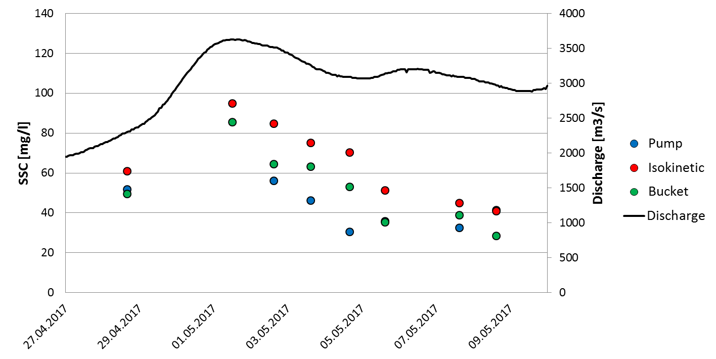
Figure 2: Comparative analysis showing the influence of different instruments used to measure suspended sediment (Photo: Sandor Baranya, not published)
After receiving metadata on sediment monitoring along the Danube River and its tributaries, e. g. locations of monitoring stations, parameters and their collection frequency, a quality check determined the variables to be collected. During the past few months, our project partners have concentrated on collecting the necessary sediment data. At the moment, monthly minimum, mean and maximum suspended sediment loads have been provided by the project partners for 60 stations, covering the time period 1986-2016. Historical data from the antecedent 30 years was gathered, where such information was available. Furthermore, daily datasets for flood events as well as typical particle size distributions were collected. The datasets are currently being assessed. Figure 1 shows an example of how water and sediment inflow in a particular stretch of the Danube can be illustrated based on aggregated data.
COMPARATIVE ANALYSIS: INFLUENCE OF DIFFERENT SAMPLING METHODS
One of the main reasons for a comparative analysis is the differences in sediment sampling methods. In the following example, sampling methods for suspended sediments are compared, thus explaining why a comparative analysis is needed. In general, suspended sediment concentrations are greatest near the riverbed and decrease upwards in the water column. In contrast, water velocity is greatest near the water surface. To measure the suspended sediment concentration (SSC), different methods can be used. The “pumping sampler method” sucks a water-sediment mixture through a pipe or hose, the intake of which is placed at the sampling point. The “isokinetic sampling method” requires the water velocity within the inlet nozzle to equal the water velocity at the depth of the sampler. This method provides a SSC that is between 50 - 60% higher than the results obtained with other methods . In order to identify the correct discharge, the correlation between the methods must be identified and the correction factor determined. Figure 2 compares the results of different SSC sampling methods as well as the calculated discharge. Sampling methods not shown in the figure are e. g. optical, nuclear, acoustic, laser diffraction and tracer techniques.
|
|
| |
|
Identifying the main components of the sediment balance
|
| |
 |
|
Figure 3: Cross-sections in the German Danube / Generic river cross-section, as calculated by TUM
(Source: Markus Reisenbüchler, TUM)
In a first step, metadata on the main components of the sediment balance equation for sections of the Danube and the main tributaries was collected via questionnaires. Project partners checked data availability by contacting the responsible authorities of their countries for the time periods 1920-1970, 1971-1990 and 1991-2016.
Based on the metadata delivered by the project partners, data sheet templates were designed to collect information on the components of the sediment balance and complementary data for its evaluation. For example, the quantification of erosion and sedimentation in river reaches, typical cross-sections, longitudinal profiles, sediment grain-size distribution curves, dredging / feeding quantities, and information on the minimum navigational water level. At the moment, the project partners are collecting the required data.
In order to understand the long-term morphological development of the Danube River, lateral changes will be evaluated and brought in relation with the sediment balance. This requires a processing of historical maps in GIS, in order to compare the former and present state of the river channel and its patterns.
EVALUATION OF CROSS-SECTIONS
The evaluation of cross-sections (see Figure 3) over time leads to the identification of river bed locations with strong sediment erosion or deposition. To compare historic changes, relevant time periods will be chosen, depending on the available data.
Since the methods for measuring and calculating the morphological changes in cross-sections often differ between countries, one common method cannot be prescribed for all. Therefore, the river-specific requirements for using a certain method must be considered. At the moment, project partners are discussing how to work with uncertainties between datasets that were collected using different methods, especially with respect to historic data.
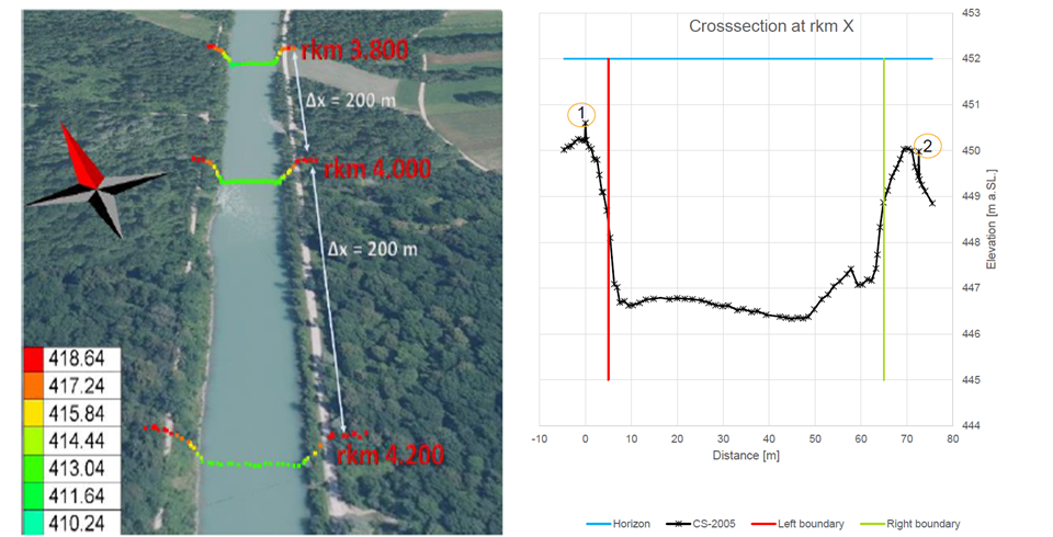
In some cases, the available data for cross-sections has to be prepared before calculation. For example, in case of echo-sound measurements of the river bottom from a boat, the cross-sections measured are not straight and deflect from previous measurements (see Figure 4). The measured values must therefore be adapted to the projected “straight” cross-section to allow comparison and evaluation of morphological changes between the two time periods.
Figure 4: Comparison of two datasets of measurements of cross-sections from a boat (Source: Katarina Mravcova, VUVH, not published)
|
|
| |
|
Collection of key-drivers for sediment discontinuity
|
| |
 |
| |
|
Figure 5: DPRSIR Framework for Reporting on Environmental Issues (Source: Smeets and Weterings, 1999)
To enable a better understanding of the reasons causing a disturbance of the sediment regime, the “key drivers of sediment discontinuity” in the Danube and its tributaries are being collected on a national level. The data collection is based on the DPSIR concept (see explanation below). In addition, the project partners will provide data describing the interactions of the sediment regime with these key drivers and determine “significant pressures” that impact sediment continuity.
Based on the structure of ICPDR shape files, a GIS databank was developed for collecting spatial data on pressure location, type etc. Technical experts from the project partners are finalizing the data collection process. The next steps concern the harmonization of collected information and the quantitative assessment of the impacts of the above-mentioned pressures.
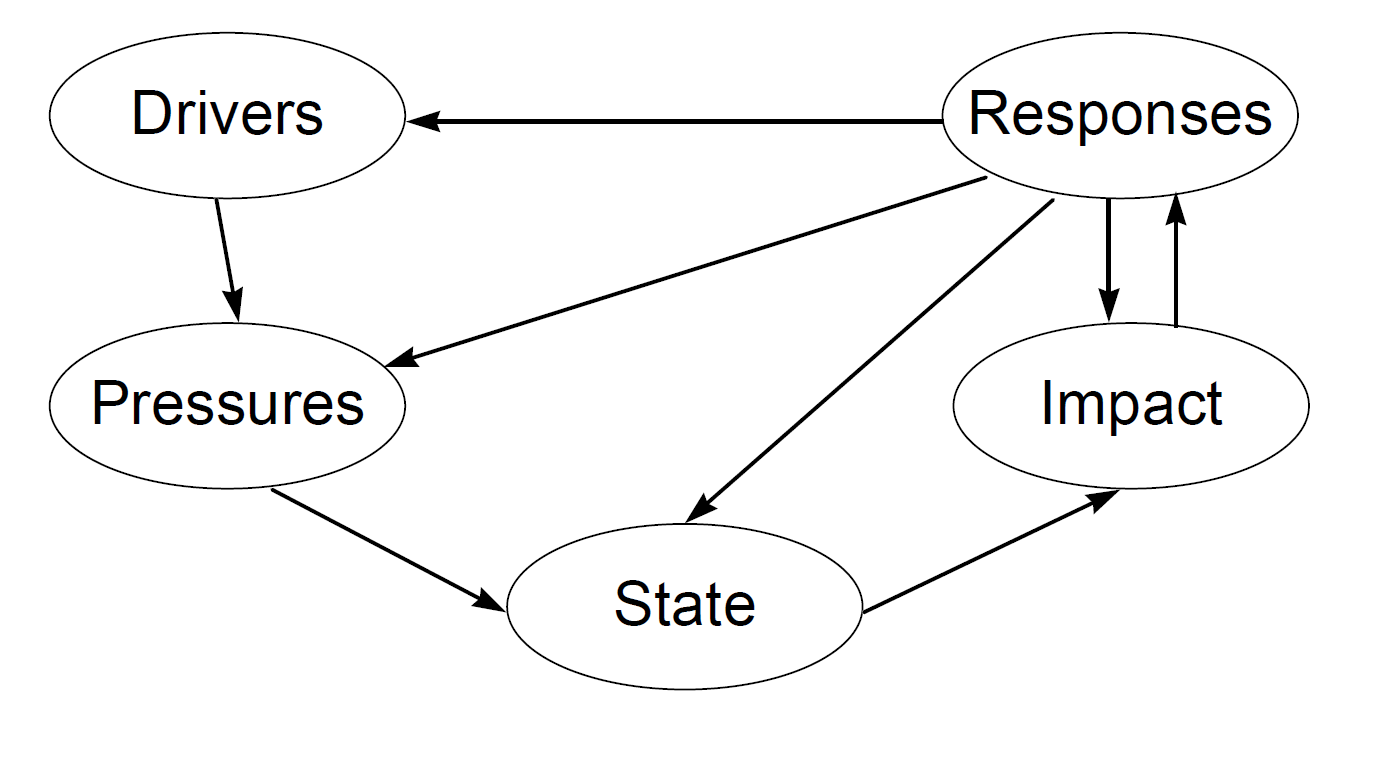
THE DPSIR FRAMEWORK
The DPSIR (Driver-Pressure-State-Impact-Response) concept is used for a pressure and impact analysis. Therefore, it is necessary to collect information on anthropogenic activities and changes that influence the state of the sediment regime. Figure 5 shows a scheme of interaction between the different factors. In a further step, the impacts are analysed and adequate responses are collected (e. g. measures taken to improve the current situation).
“According to this systems analysis view, social and economic developments exert Pressure on the environment and, as a consequence, the State of the environment changes, such as the provision of adequate conditions for health, resources availability and biodiversity. Finally, this leads to Impacts on human health, ecosystems and materials that may elicit a societal Response that feeds back on the Driving forces, or on the state or impacts directly, through adaptation or curative action.“
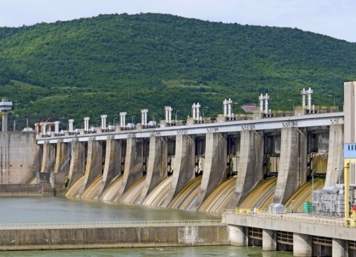
Figure 6: Hydropower – one of most important key drivers (Source: Pixabay)
In the frame of the DanubeSediment project, following key drivers were identified: hydropower; navigation (including gravel extraction for navigation purposes); flood protection; agriculture; water supply for population and industry; gravel extraction for other purposes than navigation (i. e. infrastructure development).
During the DPSIR analysis, the main significant pressures that affected the sediment balance and transport continuity have been identified: dam, weir, ship locks, barriers for slope silt / sediment drainage, groins, dredging to allow navigation and ensuring flood protection, dredging for other purposes (i. e. infrastructure works), river channel maintenance, regularization works of river channel, artificial channels (for flood protection, navigation, diversion, etc.).
|
|
| |
|
Some information on the Danube Transnational Programme
|
| |
 |
| |
|
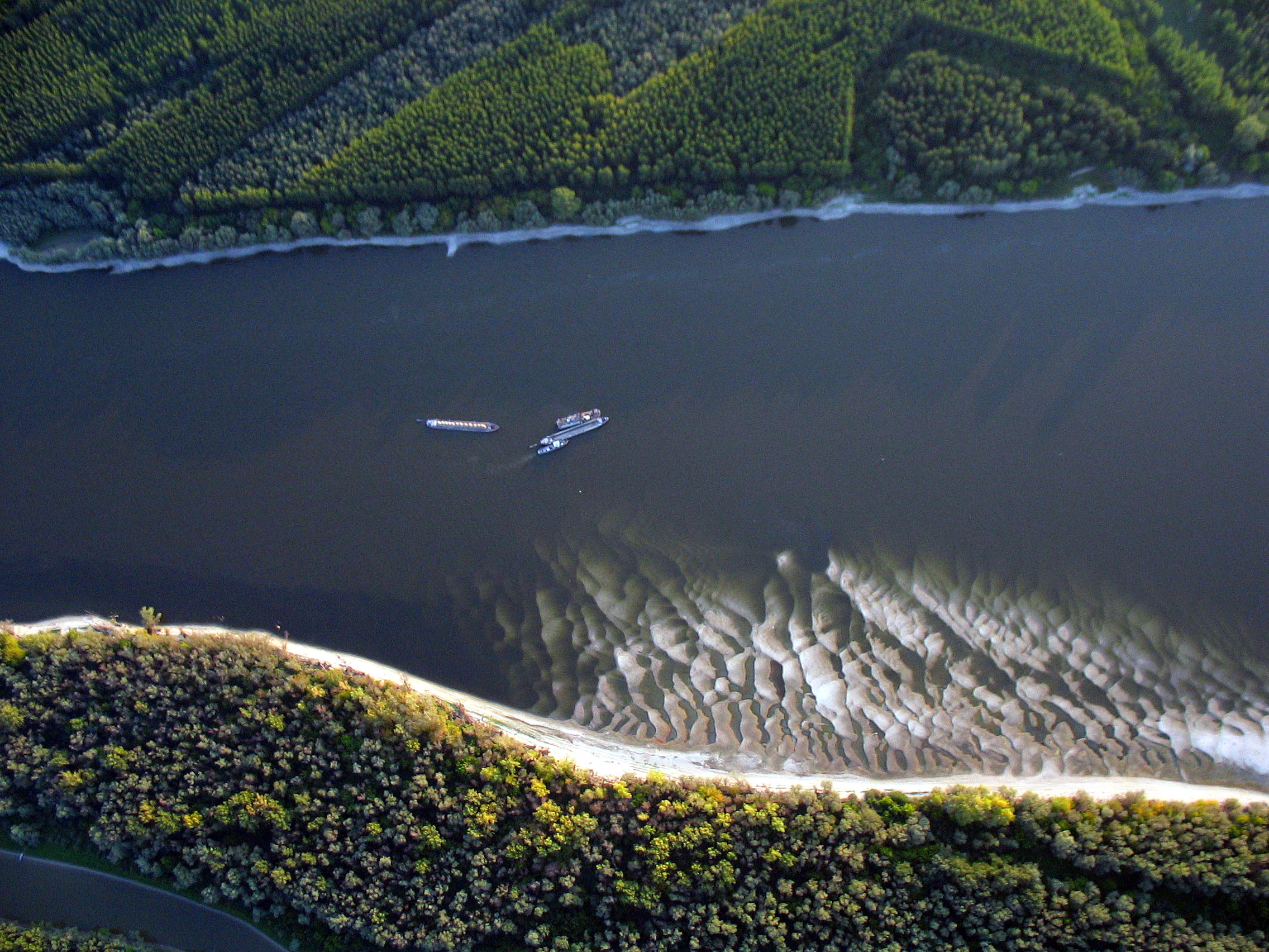
Figure 7: The Danube River in Hungary (Source: Keve Gabór)
DanubeSediment project is currently one of 54 projects approved through the financing instrument of the Interreg V B Danube Transnational Programme (DTP). DTP itself is one of the programmes of the European Territorial Cooperation (ETC), better known as Interreg. Initiated in 1989, the aim of Interreg is to stimulate cooperation between regions within the European Union. The “V” stands for “5”, signifying the 5th Interreg funding period between 2014 and 2020. The letter “B” indicates that DTP is a programme in the “transnational” or “B” strand. Transnational programmes involve national, regional and local authorities and aim to promote better integration within the Union through the formation of large groups of European regions.
The ETC has 15 transnational programmes, including the DTP. Other areas are for example Alpine Space, Central Europe or the Mediterranean region. Interreg B programmes support the development of common orientations, frameworks and strategies, the practical implementation of transnational tools and services or pilot activities etc. However, Interreg B does not fund the building of infrastructure or research equipment.
In addition to transnational programmes (B), ETC covers 88 cross-border programmes (strand “A”), the interregional programme Interreg Europe (strand “C”) and three networking programmes (INTERACT, URBACT and ESPON). Interreg A supports cooperation between regions from at least two different Member States that have common borders or are adjacent to them and wish to tackle issues that are relevant in the border region, e. g. infrastructure, tourism or industry. Interreg C helps regional and local governments from countries across Europe to work on issues of common interest and share best practice examples, e. g. by developing better policies.
The Danube Transnational Programme defines itself as a “financing instrument with a specific scope and an independent decision making body. It supports the policy integration in the Danube area … below the EU-level ... and above the national level in specific fields of action.”
The programme area covers nine Member States (Austria, Bulgaria, Croatia, Czech Republic, Hungary, the states of Baden-Württemberg and Bayern in Germany, Romania, Slovakia and Slovenia) and five non-EU Member States (Bosnia and Herzegovina, Moldova, Montenegro, Serbia and 4 provinces of Ukraine).
The total budget of DTP is 274 578 077 Euros, including the EU support of 231 924 597 Euros and the national counterpart of 42 653 480 Euros.
The DTP cooperation is structured across four priority axes:
- Innovative and socially responsible Danube region
- Environment and culture responsible Danube region – the priority axis that includes the DanubeSediment project
- Better connected and energy responsible Danube region and
- Well-governed Danube region.
For more information on the European Territorial Cooperation (ETC): http://ec.europa.eu/regional_policy/de/policy/cooperation/european-territorial/
For more information on the Danube Transnational Programme:
http://dtp.interreg-danube.eu/
|
|
| |
 |
events
|
|
UPCOMING EVENTS
- DanubeSediment National Stakeholder Romania, 14 March 2018, Bucharest, venue to be published
- DanubeSediment Expert Training on Sediment Monitoring, 18-19 April 2018, venue to be published
- DanubeSediment National Stakeholder Meeting, Bulgaria, 23-27 April 2018, venue to be published
- Danube Day will take place in all participating countries along the Danube River Basin in June 2018, see http://www.danubeday.org/international for more details.
- DanubeSediment Management Workshop, December 2018, Bucharest, date and venue to be published.
PROJECT EVENTS IN 2017
|
|
| |
|
Interesting links
|
| |
|
| |
|
published by
|
| |
|
|
|
|
| |
|
If you have received this newsletter, you have been included on one or more of the Danube Transnational Programme/projects postal mailing lists. We are committed to respect and protect the privacy of personal data collected. We regard your personal data as confidential information and will never communicate it to third parties. Your personal data are used mainly for the express purpose of receiving the newsletter. Your mailing details may also be used by the DTP and its projects for information and dissemination purposes strictly related to the programme and its projects. If you prefer not to receive more of this newsletter and your data not to be used for dissemination purposes, you can unsubscribe by sending a reply email.
|
|
|
|
|
|
