|
|
| |
| |
 |
Table of contents
|
| |
- What did the DanubeSediment project achieve?
- What are the next steps for sediment management?
- International stakeholder dialogue on sediment management
- The Sediment (Un-)Balance of the Danube
- Measures to Improve the Sediment Balance
|
|
| |
|
What did the danubesediment project achieve?
|
| |
|
Between January 2017 and November 2019, the DanubeSediment project worked on a large number of activities – each having the overall goal to improve sediment and water management in the Danube River Basin!
First of all, we compared the different monitoring instruments and methods used to collect sediment data by the Danubian countries. Our handbook offers recommendations to improve sediment monitoring. For example, we recommend installing new monitoring stations and establishing a harmonized transnational sediment quantity monitoring network with a centralised sediment data bank.
Another major package was the analysis of the sediment balance of the Danube and its major tributaries. Our results (see The Sediment (Un-)Balance of the Danube) show that the sediment regime has severely changed, with free-flowing sections being prone to erosion, whilst impoundments lead to sedimentation. Socio-economic development, namely flood protection, hydropower, navigation, water supply and commercial dredging are the main drivers of these changes.
Building on the results of a preliminary risk assessment, which analysed how changes in the sediment regime may cause an environmental risk, our project recommends a sustainable management of sediment in the Danube. Read more on the methodology applied for pilot sites in the Upper, Middle and Lower Danube and the results in the report. To improve sediment management in the Danube, our project collected good-practice measures.
Another main objective was to raise awareness about the importance of sediment for water management. In this sense, we reached a major milestone: The ICPDR identified the alteration of the sediment balance as a new sub-item under the existing Significant Water Management Issue “Hydromorphological alterations”. This means that sediment will be directly addressed in their upcoming Danube River Basin Management and Flood Risk Management Plans.
|
|
| |
|
What are the next steps in sediment management?
|
| |
|
Besides analysing the sediment balance of the Danube, our project aimed to improve sediment management in the river. To achieve this, we need to work together on the river basin scale, placing an emphasis on cross-sectoral cooperation. We therefore recommend to develop an integrated Danube River Basin sediment management concept, which operates on a transboundary level. This concept must balance environmental and socio-economic values, operate on different spatial and temporal scales and include upstream–downstream relationships.
We also recommend that sediments, respectively sediment management, become an integral part of the National River Basin and the Flood Risk Management Plans. You will find all our recommendations for technical and governance-related aspects – in the Danube Sediment Management Guidance, which will soon be uploaded to our website.
|
|
| |
 |
International stakeholder dialogue on sediment management
|
| |
| One aspect that all our recommendations have in common, is the need for direct cooperation between stakeholders. This means that any action in the field of sediment management needs to involve the relevant stakeholders – be it on a regional, national or international level. |
|
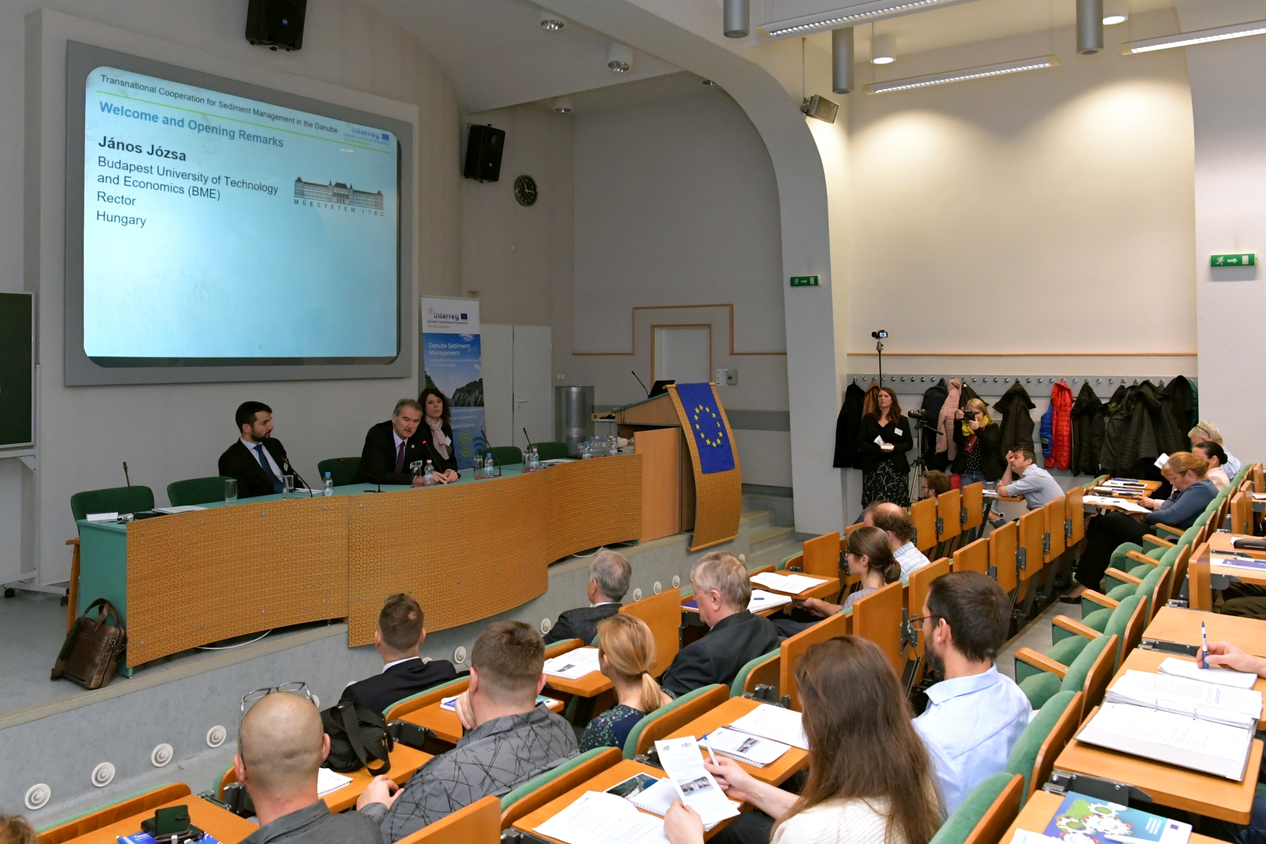 |
To initiate this stakeholder dialogue, our project consortium organised many stakeholder events and expert workshops during the past three years. They also held individual consultations to increase awareness for sediment issues amongst stakeholders, especially those working in water administration. Our final stakeholder event recently took place in Budapest (see news). In total, we involved around 500 stakeholders from the whole river basin. Our stakeholders, especially the 14 associated strategic partners, played a crucial role in finalising our project results and recommendations. For example, close cooperation with hydropower companies on discussing sediment balance data led to several new project ideas, such as the implementation and monitoring of pilot measures to improve sediment management at hydropower dams.
To ensure that stakeholder involvement in sediment management continues beyond our project, the ICPDR Secretariat in Vienna will take over the task on the international level. For example, they will involve stakeholders in the next consultation phase of the Danube River Basin Management Plan and in the development of a future sediment management concept for the Danube River Basin. If you are interested in national activities pertaining to sediment management of the Danube, please contact your national representatives (see list).
|
| |
 |
The sediment (un-)Balance of the Danube
|
| |
|
The first sediment balance of the Danube River is finished! For almost two years, our partners gathered, sorted and analysed sediment data. In summary, this analysis shows that the sediment regime in the Danube River has severely changed: free-flowing sections are prone to erosion due to higher transport capacities and a lack of sediment continuity, while the reduced energy slope in the impoundments leads to sedimentation.
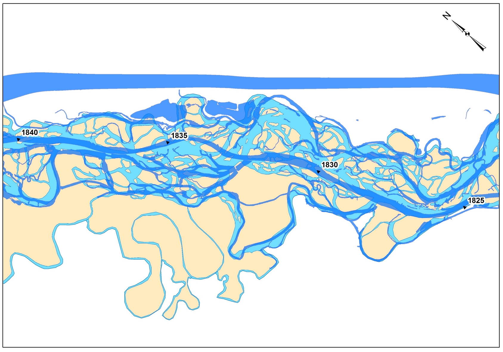
In the Upper and Middle Danube, large-scale engineering transformed the formerly complex river morphology to a uniform channel over large stretches. By using historic maps, the changes in the length of the Danube were calculated. The river length was reduced by 134 km, which means that the Upper Danube is now 11 % and the Middle Danube is 4 % shorter. In addition, the average river width was reduced by about 39 % in the Upper and by about 12 % in the Middle Danube (see example in Figure 1). In the Lower Danube River, the length was marginally reduced by around 1 % and the average width by 4 %. To find out more, you can zoom into maps of the historic and present river course in our interactive map.
|
|
|
|
Figure 1 Changes in the Danube river course along the Slovakian-Hungarian border (see river kilometres). Light blue represents the historic river course with islands in beige from the time period around 1850-1900 and darker blue shows today’s river course. Source: VUVH, Slovakia
|
As seen in Figure 2 below, the total suspended sediment input to the Danube Delta and the Black Sea has decreased by more than 60 %. Former amounts ranged from about 60 Mt/yr and 40 Mt/yr, whilst nowadays only about 20 Mt/yr and 15 Mt/yr enter the Delta and the Sea.

Figure 2 Suspended sediment balance along the Danube River and its major tributaries before (left) and after (right) construction of the HPPs on the Danube River. Source: BOKU, Austria
In addition to sediment transport data, our partners also looked at bathymetrical data, bed material as well as dredging and feeding to calculate the sediment balance. The map in Figure 3 shows erosion and sedimentation reaches for time period 1986 to 2016. In total, about 729 river kilometres (29 %) of the Danube River are dominated by erosion and 911 rkm (36 %) by sedimentation. In the Lower Danube, 670 rkm (26 %) show an erosional trend, but a lack of data hinders a detailed analysis, meaning local sedimentation may exist in stretches of general riverbed erosion. Thus, about 55 % of the river length, including reaches without sufficient data for a detailed analysis, are facing erosional tendencies. 241 rkm (9 %) of the Danube River show a dynamic balance prevails, which means there were no significant changes. Detailed information on the sediment balance analyses will be available on our website shortly.
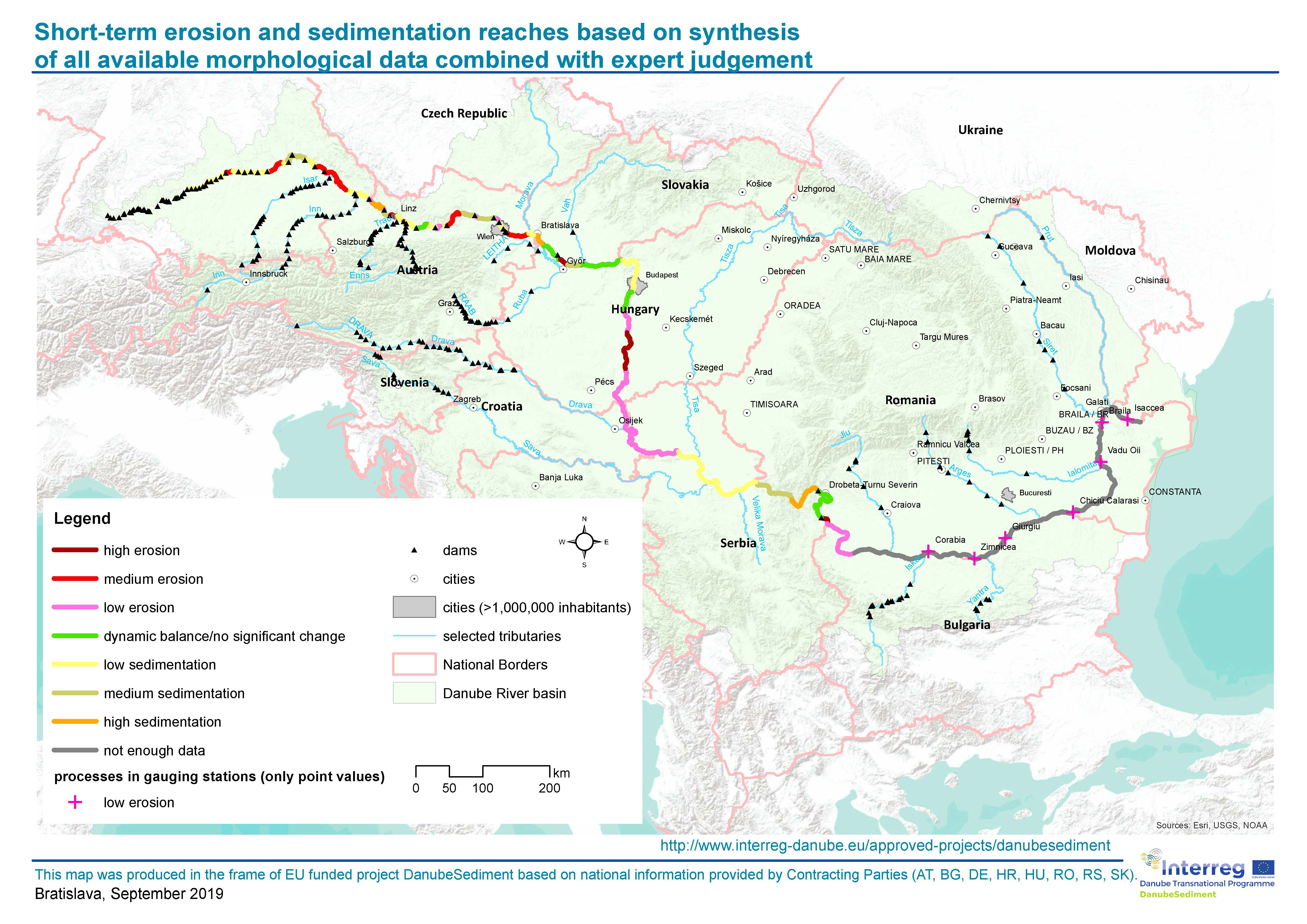
Figure 3 Reaches of the Upper, Middle and Lower Danube showing sedimentation and erosion (data from the period between 1986 and 2016). Source: VUVH, Slovakia
|
| |
|
Measures to improve the sediment balance
|
| |
|
According to the results of our sediment balance analysis and the preliminary risk assessment, we need more sustainable sediment management in the Danube. Our project partners therefore collected over 70 different good practice examples that reduce erosion and sedimentation in rivers. These were summarised into 38 generic measures and divided in four application areas: the free flowing section, the reservoir or impoundment, the catchment area and the embankment zone (see “Sediment Management Measures for the Danube” in our Library).
When selecting adequate measures, one needs to consider how they impact the morphological parameters and how they act on a spatial and temporal scale. In addition, the feasibility of a measure as well as its impact on ecology and other water users needs to be analysed. Therefore, an integrated planning needs to include the expertise of relevant stakeholders from the beginning, especially when it comes to measures relating to hydropower, navigation, flood risk and river management, including ecology. The Sediment Manual for Stakeholders directly addresses these key stakeholders by categorising the measures relevant for each sector. We are currently finalising the publication, which will be available soon. In the meantime, enjoy our project video, which introduces good practice measures to reduce erosion and sedimentation in the river.
|
|
| |
|
Interesting links
|
| |
|
| |
|
Published by
|
| |
|
|
|
|
| |
|
If you have received this newsletter, you have been included on one or more of the Danube Transnational Programme/projects postal mailing lists. We are committed to respect and protect the privacy of personal data collected. We regard your personal data as confidential information and will never communicate it to third parties. Your personal data are used mainly for the express purpose of receiving the newsletter. Your mailing details may also be used by the DTP and its projects for information and dissemination purposes strictly related to the programme and its projects. If you prefer not to receive more of this newsletter and your data not to be used for dissemination purposes, you can unsubscribe by sending a reply email.
|
|
|
|
|
|
